As announced on my blog before, last weekend I went to the OpenStreetMap (OSM)-conference in Amsterdam, called the ‚State of the Map‚. The schedule featured a dense program of interesting talks, and several coffee breaks for networking. This year the Friday was the business-day, filled with talks about data quality and using OSM data in applications. Saturday and Sunday were dedicated to the community, with talks about the state of the OSM in different countries, new challenges for the project as it gets bigger and bigger and applications, applications, applications.
Some of the things which were interesting to me on the conference:
Data quality is a big issue for most of the people I talk with, people just can’t imagine, that data collected by a community can compete with commercial data. It is true, that the OpenStreetMap still has big white holes, especially on the country side. On the other hand completeness in the densely built-up areas (especially Europe) is much higher than in commercial map data (points of interests, foot- and cycleways, …), although assessment of this data shows, that most of the data has been created by a couple of people. Still, comparison of the street data with commercial data (done in the UK with Ordnance Survey data) show a very high correlation. A big advantage of the OpenStreetMap is the high actuality of the data, data often gets uploaded as soon as changes in the real world happen.
One big advantage of the OpenStreetMap is the big community. In March of this year the 100.000th user registered, last week there were already 135.000 users. For sure not all users are really active in the project, but at least about 10.000 users were active during the last two months. The big players in mapping business (Navteq, Teleatlas) have around 800 employees. The next goal for the OpenStreetMap are 1.000.000 registered users, for this, the project has to become more user friendly and faster.
Talking about user friendliness, one very interesting project are the ‚Walking Papers‚, designed by Michael Migurski (who I unfortunately failed to have a chat with. I wanted to talk about another of his projects, Cascadenik, which is used by my project OpenStreetBrowser). The idea is as brilliant as it is simple – you print a map of the region you are interested in, as you walk around you mark missing details (points of interests, roads, road names), scan the papers back in and upload them to the server, where they became available as background in your (and everybody elses) editor, to be drawn after. You don’t even need a GPS for this, because you can guess the position on the map. If you don’t have a scanner, you can send your papers per mail to some address, and they get scanned in for you.
It’s not possible to fit all interesting things I learned on the conference into this blog post, therefore I recommend you the video site of the conference, where eventually all talks will appear (hopefully; from last year still some talks are missing). All pictures uploaded to Flickr got the tag sotm09, all twitter messages got the tag #sotm09. On more link: a new webpage showing some great examples of mapping efforts: bestofosm.org.
In total about 250 people (mostly male geeks) attended the conference. I had the opportunity to talk to some of them and present my project the OpenStreetBrowser. Most were pretty impressed – I still hope it gets famous ;)
 A cake with a map (made from OSM data, CC-BY-SA) |
 people eating cakes, drinking coffee and networking |
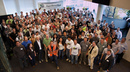 Group photo of most conference participants on Sunday afternoon |