As I got stuck in Bulgaria, looking for flat-mates, I continued my work on my OpenStreetMap-Project, I was mentioning earlier on my blog (in fact I was not talking about this project since beginning of November).
As I already said, the OpenStreetMap is the Wikipedia of geographical data. The data is collected by volunteers or imported from free data sources (e.g. gouvernmental data if available or free satellite images). In Austria a company – plan.at – donated their data, as mapping is not their main business anymore. This improved the Austrian part of the OpenStreetMap greatly, especially on the countryside (although the import is not finished yet).
My project consists mainly of two parts. The first – and main part – is an interface to browse the available information in the OpenStreetMap. E.g. if you are looking for a pub or the nearest fuel station. But this is not the part I want to talk about this time.
The second part is an improved rendering of the OpenStreetMap. I’m not very satisfied with the default rendering, it looks very pale. I decided to make it more flashy. Additional various overlays can be displayed, e.g. the routes of public transportation (which none of the default renderers of OpenStreetMap do yet).
Attention, technical details: I’m using Mapnik as render engine, the same as the default view of the OpenStreetMap uses. To make developing of the new style easier, I’m using Cascadenik, a kind of CSS for Mapnik.
As I don’t want to announce my project here (it’s still quite buggy and slow), but I want to talk about it, I will show you some example renderings:
 |
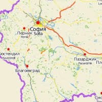 |
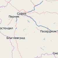
| In the first example you can see a part of Bulgaria. As you can see the country borders are clearer, and the names of the Cities are displayed in the country language and in the English translation (as available). | |
 |
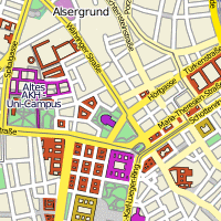 |
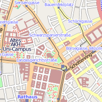
| In the second example you can see the surroundings of Schottentor in Vienna. Buildings have different colours, depending on their function and a little border. | |
 |
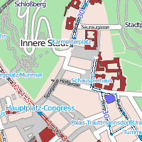 |
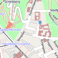
| The last example shows the inner city of Graz with an overlay of the routes of public transportation. | |
I’m busy developing on my application, I hope to be able to show you more of it soon.