As I told I’m gonna present some features of the OpenStreetBrowser from time to time. It’s also a good documentation for the project.
Routes of public transportation
Routes of public transportation are still not being displayed on the main Mapnik and OsmaRender renderings, although they are very important in my opinion. For me this was actually the start of the project, I had planned to make a nice map with public transportation routes. Now they are only an overlay, as they would clutter the main map too much.
There are two noteworthy features: The references of routes sharing the same way get collected and separated by ‚,‘, which looks much better, and stops with the same name get combined and get a box drawn around. Both of these features improve visibility.

Link to Wikipedia
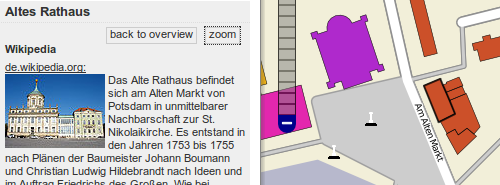
In the OpenStreetMap it’s possible to link to the Wikipedia. The key is „wikipedia:language“, e.g. „wikipedia:en“ or „wikipedia:de“. If such a link exists, the OpenStreetBrowser displays an abstract of the article and an image, when it finds one (it has to be before the first abstract … this is something still to improve).

Stylesheet for the Overlays
The last feature for this time is the newest feature. The styles of the Overlays „Food & Drink“, „Shops“, „Culture & Tourism“ and „Services“ is generated from a page in the OSM-Wiki. So if you find something missing on these overlays, or you have better icons (many objects don’t have an icon or share icons with other features), feel free to upload them there (the new style sheet will be used after the next database reload, so typically after 1-3 weeks).

If you have suggestions for new feature, complaints or praise, feel free to leave me a comment :)
I like your approach to data presentation, mostly because it follows European mapping standards (colours, line thickness, what is on the map etc).
I’d like to use it more often, but the server simply stalls. It takes up to a few minutes to display anything at closer zooms.
Is there a way to help you render the map?