Archive for the ‘Project’ Category

Some Features of the OpenStreetBrowser

Montag, April 13th, 2009

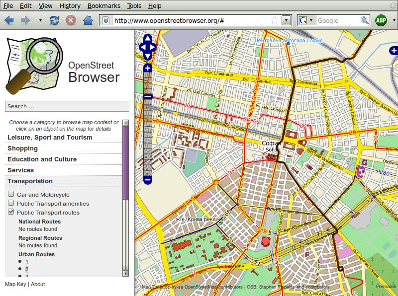
This time I want to show you some features of the OpenStreetBrowser. One of the goals of my project is to display as many information as possible in a simple and understandable way. Sounds like the quadratur of the circle? Maybe it is :)

Housenumbers

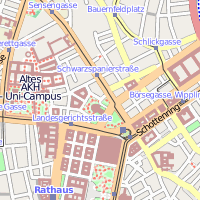
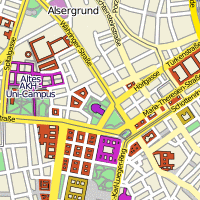
The first feature I want to show you are house numbers. Sounds rather boring, isn’t it? The default Mapnik and Osmarenders styles don’t rotate the numbers, so it’s hard to say where they belong to. It’s also a problem of the software (I can only speak for Mapnik, because I’m using it too), there isn’t really a possibility to rotate texts and icons. So you have to use crude workarounds, which are a pain in the ass. But I think I’ve done a pretty good job … although ideas for improvements are always welcome! The house numbers are also being listed in the details of the street in the side pane.

Housenumbers in Vienna

More informations about entering house numbers to OSM.

Cemetery

I don’t know about you, my precious reader, but I like visiting cemeteries. Maybe it’s a Viennese thing, they were always crazy about their afterlife. On cemeteries you can visit all these graves of famous people. Even better if you can see them on the map, isn’t it? The important graves on a cemetery are also listed in the side information pane. Time to visit your local cemetery!

What is still missing is the background of the cemeteries, at the moment there are theses crosses, which is not really appropriate for graves of other religions.

Waldfriedhof Dahlem in Berlin

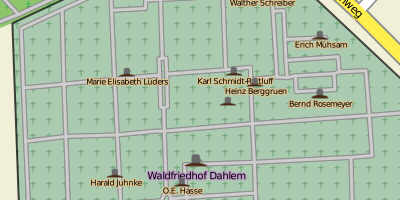
There is no approved method for tagging graves in OSM yet, the OpenStreetBrowser currently accepts cemetery=grave and historic=grave.

Borders

Places (Countries, Regions, Cities, Villages, …) are only entered as Point (Node) to the OSM right now. In many cases you also have borders, but it’s hard to see them and the information which border belongs to which node is missing. The OpenStreetBrowser combines the borders and the nodes and shows both of them if you see the places‘ details.

City border of L’Aquila

The border is a relation of the type boundary or multipolygon, the tag admin_level matches more or less to the place-tag. To help find the correct border add the node to the relation and give it the role ‚label‘ (which is a proposed feature).

These were just three of the features of the OpenStreetBrowser. I will show you more another time.  If you have some ideas or questions, you can post them as comment here or to this page.

*drumroll* The OpenStreetBrowser

Dienstag, März 24th, 2009

I’m very happy, that I finally can publicly announce the project I was working on the last months. I already told you about the OpenStreetMap, this astonishing project with the goal of creating a free map (as in free speech and in free beer) of the world. The great thing about it … you can take the data, use your imagination and think of better ways to visualize the data. And I used my imagination and creativity and created the OpenStreetBrowser.

On the webpage you have a „Slippy Map“, as you know it from the OpenStreetMap Homepage or commercial services like Google Maps. But on the left side you can investigate the current map view. Get a list of Pubs or the Public Transport routes or a list of street names. When appropriate a thematic overlay is displayed. Just play with it, you will see you can’t stop :) If you want to get more information about an object, then just click on it on the map.

Screenshot of OpenStreetBrowser
So. I don’t want to go into more detail here. Just give it a try. If you want more information there’s a page in the OpenStreetMap-Wiki for the project.

Disclaimer: The project is not finished yet, it’s still a big construction site. So, please be patient if it gets slow or if you find bugs (please report them here) or something is still missing.

I want to send special thanks to Manuela for talking and encouraging and for sure for the web design. I’m looking forward for further co-operation. And I also want to thank Monika for mental assistance :)

Welcome to my new Blog!

Sonntag, März 22nd, 2009

Hi everybody! Welcome to my new blog on plepe.at. I finally decided, that I’m not totally happy with twoday.net and had planned to buy my own domain anyway … So here it is.

To have all the stories of my blog together I copied all of them from my old address plepe.twoday.net. But unfortunately I couldn’t copy the comments you wrote me. So you will find these on my old address.

Just to tease you a little bit: You can expect a very exciting post here … at least I’m totally excited about it :) I’m finally gonna present you my project!

Teaser for my OpenStreetMap-Project

Dienstag, Februar 17th, 2009

As I got stuck in Bulgaria, looking for flat-mates, I continued my work on my OpenStreetMap-Project, I was mentioning earlier on my blog (in fact I was not talking about this project since beginning of November).

As I already said, the OpenStreetMap is the Wikipedia of geographical data. The data is collected by volunteers or imported from free data sources (e.g. gouvernmental data if available or free satellite images). In Austria a company – plan.atdonated their data, as mapping is not their main business anymore. This improved the Austrian part of the OpenStreetMap greatly, especially on the countryside (although the import is not finished yet).

My project consists mainly of two parts. The first – and main part – is an interface to browse the available information in the OpenStreetMap. E.g. if you are looking for a pub or the nearest fuel station. But this is not the part I want to talk about this time.

The second part is an improved rendering of the OpenStreetMap. I’m not very satisfied with the default rendering, it looks very pale. I decided to make it more flashy. Additional various overlays can be displayed, e.g. the routes of public transportation (which none of the default renderers of OpenStreetMap do yet).

Attention, technical details: I’m using Mapnik as render engine, the same as the default view of the OpenStreetMap uses. To make developing of the new style easier, I’m using Cascadenik, a kind of CSS for Mapnik.

As I don’t want to announce my project here (it’s still quite buggy and slow), but I want to talk about it, I will show you some example renderings:

In the first example you can see a part of Bulgaria. As you can see the country borders are clearer, and the names of the Cities are displayed in the country language and in the English translation (as available).
In the second example you can see the surroundings of Schottentor in Vienna. Buildings have different colours, depending on their function and a little border.
The last example shows the inner city of Graz with an overlay of the routes of public transportation.

I’m busy developing on my application, I hope to be able to show you more of it soon.